On the Establishment of the Area Temporarily Prohibited for Navigation in the Occupied Ukrainian Territorial Sea Adjacent to the Crimean Peninsula
Bohdan USTYMENKO, M.J., Attorney at Law
Tetiana USTYMENKO, S.J.D., professor,
Department of Civil Law and Procedure
National Academy of Internal Affairs
Article 1 of the Constitution of Ukraine [1] establishes that Ukraine is a sovereign independent democratic social state governed by the rule of law.
According to the provisions of Article 2 of the Constitution of Ukraine, the sovereignty of Ukraine extends to its entire territory that is integral and inviolable within the existing border.
At the same time, Paragraph 1 of Article 2 of the United Nations Convention on the Law of the Sea [2] (hereinafter — UNCLOS or Convention) states that the sovereignty of a coastal state extends beyond its land and inland waters to the adjacent maritime zone referred to as «the territorial sea.»
The sovereignty also extends to airspace over the territorial sea, as well as to its bed and subsoil (Paragraph 2, Article 2 of the UNCLOS).
In addition, Article 3 of the UNCLOS establishes that each state has the right to set the breadth of its territorial sea up to a limit not exceeding twelve nautical miles, measured from baselines defined in accordance with the UNCLOS.
In turn, Article 25 (1) of the UNCLOS allows a coastal state to take the necessary steps in its territorial sea to prevent a non-innocent passage.
As is apparent from Article 19 (1) of the UNCLOS, a passage is considered peaceful if it proceeds in accordance with the Convention and other rules of international law and does not breach peace, good order or security of the coastal state.
In accordance with Paragraph 2 of Article 19 of the Convention, a passage of a foreign vessel is considered to be in breach of the peace, good order or security of a coastal state if it engages in the following activities in the territorial sea:
- any threat or use of force against the sovereignty, territorial integrity or
- political independence of the coastal State, or in any other manner in
- violation of the principles of international law embodied in the Charter of
- the UN
- any exercise or practice with weapons of any kind
- any act aimed at collecting information to the prejudice of the
- defense or security of the coastal state
- any act of propaganda aimed at affecting the defense or security
- of the coastal state
- the launching, landing or taking on board of any aircraft
- the launching, landing or taking on board of any military
- device
- the loading or unloading of any commodity, currency or person
- contrary to the customs, fiscal, immigration or sanitary laws and
- regulations of the coastal state
- any act of willful and serious pollution contrary to the UNCLOS
- any fishing activities
- any research or survey activities
- actions aimed at interfering with any systems of communication
- or any other facilities or installations of the coastal state
- any other activity that doesn’t have a direct bearing on passage.
Meanwhile, a coastal state may adopt laws and regulations conforming with the provisions of the UNCLOS and other rules of international law relating to innocent passage through the territorial sea in respect to all or any of the following:
- safety of navigation and regulation of maritime traffic
- protection of navigational and other aids, facilities or installations
- protection of cables and pipelines
- conservation of the living resources of the sea
- prevention of infringement of the fisheries laws and
- regulations of the coastal state
- preservation of the environment of the coastal state and
- prevention, reduction and control of pollution thereof
- marine scientific research and hydrographic surveys
- prevention of infringement of the customs, fiscal,
- immigration or sanitary laws and regulations of the coastal
- state (Article 21 (1) of the Convention).
Additionally, without discrimination in form or in fact among foreign ships, a coastal state may temporarily suspend in specified areas of its territorial sea the innocent passage of foreign ships if such suspension is essential for the protection of its security, including weapons exercises. Such suspension shall take effect only after having been duly published. (Article 25 (3) of the UNCLOS).
Finally, Article 24 (2) of the Convention stipulates that a coastal state must give appropriate publicity to any known danger to navigation within its territorial sea.
In this context, it should also be noted that according to Article 1 of the Law of Ukraine On the State Border of Ukraine [3] (hereinafter — the State Border Law), the state border of Ukraine is a line and a vertical surface that stretches along that line that determine the boundaries of the territory of Ukraine over land, water, subsoil and airspace.
The state border of Ukraine is defined by the Constitution and laws of Ukraine, as well as by the international treaties of Ukraine approved by the Verkhovna Rada of Ukraine.
According to Article 3 of the State Border Law, the state border of Ukraine at sea, unless otherwise stipulated by the international treaties of Ukraine, is established on the outer border of the territorial sea of Ukraine.
According to Article 5 of the State Border Law, the territorial sea of Ukraine includes coastal waters extending for twelve nautical miles from the lowest water line both on the mainland and in the islands belonging to Ukraine or from direct baselines connecting the corresponding points. The geographical coordinates of these points are approved in the order established by the Cabinet of Ministers of Ukraine.
In some cases, a different breadth of Ukraine’s territorial sea may be established by international treaties of Ukraine, and in the absence of treaties — in accordance with the generally recognized principles and norms of international law.
At the same time, in accordance with Article 17 of the Law on State Border, respective Ukrainian authorities may establish areas in the territorial sea and inland waters of Ukraine where navigation and stay of Ukrainian and foreign non-military ships and warships is temporarily prohibited. The establishment of such areas has to be announced in due course.
Also, Paragraph 6 of the Rules of Navigation and Stay of Foreign Warships in the Territorial Sea, Inland Waters, Raids and Ports of Ukraine [4] stipulates that foreign warships must not enter and remain in the areas of territorial sea and inland waters where navigation is prohibited.
Nor should we ignore another international instrument critically important to the ocean safety, namely, the International Convention for the Safety of Life at Sea [5] (as amended) (hereinafter — SOLAS).
Thus, under Regulation 4 Navigational Warnings of SOLAS Chapter V Safety of Navigation, each contracting government shall take all necessary measures to ensure that when intelligence of any dangers is received from whatever reliable source, it must be promptly brought to the knowledge of those concerned and communicated to other interested governments.
Moreover, the provisions of Regulation 9 Hydrographic Services of SOLAS Chapter V stipulate that the contracting governments undertake steps to collect and compile hydrographic data, as well as publish, disseminate and update all maritime information necessary for safe navigation. In particular, the contracting governments undertake to cooperate in carrying out, as far as possible, the following navigation and hydrographic services in a manner most suitable for the purpose of aiding navigation:
- ensure that hydrographic surveying is carried out, as far as possible, adequate to the requirements of safe navigation
- prepare and issue nautical charts, sailing directions, lists of lights, tide tables and other nautical publications, where applicable, satisfying the needs of safe navigation
- promulgate notices to mariners in order that nautical charts and publications are kept, as far as possible, up to date and
- provide data management arrangements to support these services.
Additionally, contracting governments are committed to ensuring that charts and navigation aids are as uniform as possible and, whenever possible, take into account relevant international resolutions and recommendations.
At the same time, contracting governments are committed to coordinating their activities to the fullest extent possible, in order to ensure that hydrographic and nautical information is made available on a worldwide scale as timely, reliably, and unambiguously as possible.
Also, pursuant to Regulation 13 Establishment and Operation of Aids to Navigation of SOLAS Chapter V, each Contracting Government, undertakes to provide, as it deems practical and necessary either individually or in co-operation with other contracting governments, such aids to navigation as the volume of traffic justifies and the degree of risk requires.
In order to achieve the greatest possible uniformity of navigation aids, contracting governments are required to take into account international guidelines and guidelines when establishing such aids. Contracting governments must also ensure that information relating to aids to navigation is made available to all concerned. Changes in the transmissions of position-fixing systems that could adversely affect the performance of receivers fitted in ships must be avoided as far as possible and only be affected after timely and adequate notice has been promulgated.
The above SOLAS provisions are duly reflected in Article 76 of the Merchant Shipping Code of Ukraine [6] (hereinafter — KTM). Namely, this article of KTM stipulates that nautical and hydrographic support of navigation in Ukraine’s inland waters, territorial sea and exclusive (marine) economic zone is provided by means of:
- installing, developing and maintaining the navigation equipment required by the intensity of the navigation traffic and the degree of navigation hazard
- conducting hydrographic surveys
- collecting navigation information
- timely preparation, publication and provision of seafarers with navigational charts, advisories, guides, messages and warnings, as well as other up-to-date navigation and hydrographic information.
In turn, Subparagraph 31 of Paragraph 4 of the Regulation on the Ministry of Infrastructure of Ukraine [7] stipulates that in accordance with the tasks laid upon the Ministry of Infrastructure of Ukraine, the latter, inter alia, approves the provisions on nautical and hydrographic support to navigation in the inland waters, territorial sea and exclusive (marine) economic zone of Ukraine.
In addition, per item 1.1 of the Regulation on the Nautical and Hydrographic Provision of Navigation in the Inland Waters, Territorial Sea and Exclusive (Marine) Economic Zone of Ukraine [8] (hereinafter — the NHPN Regulations), the Nautical and Hydrographic Support (hereinafter — NHS) of navigation means facilitating navigation-friendly conditions by installing and maintaining navigation aids (hereinafter — navaid) required by the intensity of the navigation traffic and the degree of hazard, conducting hydrographic surveys and publishing and disseminating up-to-date nautical and hydrographic information per requirements of the International Maritime Organization (hereinafter — IMO).
In general, as stipulated in item 1.2 of the NHPN Regulation, NHS is a specialized service pertaining to the organization of maritime safety that is provided to maritime vessels in accordance with Ukraine's international obligations.
Specifically, the nautical and hydrographic support is provided via:
- equipping the seas with coastal — lighthouses, navigation signs, navaids, radio- and e-navigation — and floating — lighthouses, buoys and poles — navigation equipment and ensuring its uninterrupted operation according to its respective operation modes, as recommended by the International Association of Marine Aids to Navigation and Lighthouse Authorities (hereinafter — IALA)
- conducting hydrographic surveys of the Black and Azov Seas for the preparation and publication of the official nautical charts, navigation guides and manuals in accordance with the International Hydrographic Organization (hereinafter — IHO) standards
- collecting information and notifying vessels of any changes in the navigation conditions and sailing modes.
In Ukraine, nautical and hydrographic support of navigation is organized and facilitated by the State Hydrographic Service of Ukraine and is financed in accordance with the current legislation (item 1.4 of the NHPN Regulations).
In respect to NHS, the State Hydrographic Service of Ukraine:
- takes part in the development of programs for the advancement and improvement of the national NHS system
- initiates the development of standards and regulatory framework governing the maritime NHS
- provides the Ukrainian seas with navigation equipment, ensuring its development, maintenance, repair and uninterrupted operation in the set mode
- conducts hydrographic surveys and oceanographic exploration in the Black and Azov Seas
- conducts topographic and geodetic works in the five-kilometer zone of the Ukrainian coast
- carries out comprehensive management in the field of mapping the seas and inland waterways
- produces nautical charts and guides in analog, digital and other forms and distributes those to seafarers
- compiles a database of hydrographic and oceanographic materials
- on the basis of hydrographic surveys, develops and drafts routes for ship traffic, maritime corridors and traffic distribution systems in the territorial sea
- through publication of the Notices to Mariners and radio navigation alerts, keeps mariners informed of any changes in navigation conditions and operation mode
- serves as the National Navigation Alert Coordinator for Ukraine within the Worldwide Navigational Warning Service (WWNWS)
- represents Ukraine in the IHO and the International Association of Marine Aids to Navigation and Lighthouse Authorities (IALA) and cooperates with the hydrographic and lighthouse services of other countries
- ensures compliance with the official international rules and standards on all NHS issues and participates in the development of new documents with the view of Ukraine’s national interests
- within its powers, approves the construction of objects on the Ukrainian coast and the Black and Azov Sea waters that may affect the navigation equipment’s established mode of operation or create a navigation hazard
- within its powers, approves the project documentation concerning the hydraulic works, construction of hydraulic structures and laying of submarine cables and oil and gas pipelines on the seas and coast of Ukraine
- provides organizational and technical support to the land-based and floating automatic identification systems (hereinafter - AIS) network it is responsible for
- provides organizational and technical support to the monitoring system’s backup routing server
- serves as the national coordinator of the international automated navigation and meteorological warning alert (NAVTEX)
- compiles and updates a list of restricted maritime zones within the jurisdiction of Ukraine (Appendix), restricting zones during year-round operation and restricting, where appropriate, the operation of certain vessel classes using the classes criteria per Article 4 (1) of the May 6, 2009 Directive of the European Parliament and Council 2009/45/EU on safety rules and standards for passenger ships
- publishes in the Notices to Mariners a list of restricted maritime zones within the jurisdiction of Ukraine and any changes to the list
- submits a list of restricted maritime zones within the jurisdiction of Ukraine and information on any changes to the central executive authority realizing state policy on maritime and inland waterway shipping, so that the latter can publish it on its official website and notify the international organizations accordingly.
So, overall, Ukraine has a well-developed regulatory framework for the nautical and hydrographic support of navigation.
At the same time, it is a generally acknowledged fact that in 2014, the Russian Federation occupied the Ukrainian territories, namely the Autonomous Republic of Crimea and the city of Sevastopol. Subsequently, in order to determine the status of the temporarily occupied territory, the Law of Ukraine On Ensuring the Rights and Freedoms of Citizens and the Legal Regime in the Occupied Territory of Ukraine [9] (hereinafter — the Law on Occupation) established a special legal regime for that area. The special regime defined the new scope and specifics of the activity of local self-government and state bodies, enterprises, institutions and organizations and compliance and protection of human and citizen's rights and rights and freedoms of legal entities.
Paragraph 1 of Article 1 of the Law on Occupation specifies that a temporarily occupied territory of Ukraine (hereinafter — temporarily occupied territory) is an integral part of the territory of Ukraine where the Constitution and laws of Ukraine apply in full. The official date of the beginning of the temporary occupation is February 20, 2014. In addition, Article 3 (1) of the Law on Occupation stipulates that for the purposes of this Law, a temporarily occupied territory is defined as:
- land area of the Autonomous Republic of Crimea and the city of Sevastopol and Ukrainian inland waters in these areas
- inland sea waters and territorial sea of Ukraine around the Crimean peninsula, as well as the territory of the exclusive (marine) economic zone of Ukraine along the coast of the Crimean peninsula and adjacent to the coast continental shelf of Ukraine within the jurisdiction of the Ukrainian state authorities per international legal norms and the Constitution and laws of Ukraine
- subsoil beneath the territories defined above and the airspace above them.
We would like to point out that due to the occupation of the Autonomous Republic of Crimea and the city of Sevastopol and other numerous illegal actions of the Russian Federation, Ukraine has lost control over most of its territorial sea and exclusive economic zone — all in all, about 100,000 square kilometers in the Black and Azov seas of the 137,000 square kilometers of sea waters total that Ukraine's sovereignty or sovereign rights extend to.
In response, the decree of Ukraine’s Ministry of Infrastructure On Closure of the Seaports [10] has closed the Ukrainian seaports of Kerch, Sevastopol, Feodosia, Yalta and Yevpatoria until the constitutional order of Ukraine in the temporarily occupied territory of the Autonomous Republic of Crimea and the city of Sevastopol is restored.
In addition, due to the inability of servicing ships and passengers, facilitating cargo, transport, freight forwarding and other related activities, ensuring proper level of navigation safety and Ukraine’s compliance with the international treaties requirements as well as adequate environmental protection at sea fishing ports in the Autonomous Republic of Crimea and the city of Sevastopol, by resolution On the Temporary Closure of the Sea Fishing Ports [11], the Cabinet of Ministers of Ukraine has closed the Kerch and Sevastopol Sea Fishing Ports until the constitutional order of Ukraine in these temporarily occupied area is restored.
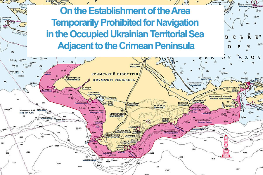
Therefore, taking into account the above facts, the requirements of the international maritime law and Ukraine’s national legislation, as well as the present objective impossibility for Ukraine to comply with the Regulation 4 Navigational Warnings, Regulation 9 Hydrographic Services and Regulation 13 Establishment and Operation of Aids to Navigation of SOLAS Chapter V Safety of Navigation in the RF-occupied inland waters and territorial sea around the Crimean peninsula, as a coastal state, Ukraine is obligated to establish within its inland waters and territorial sea around the Crimean peninsula an area where navigation and stay of Ukrainian and foreign non-military vessels and warships is temporarily prohibited until Ukraine’s constitutional order there is restored.
Maps of the Area Temporarily Prohibited for Navigation in the Occupied Ukrainian Territorial Sea Adjacent to the Crimean Peninsula
/01-2020-AK/map mein 01-m.jpg)
/01-2020-AK/map mein 02-m.jpg)
/01-2020-AK/map mein 03-m.jpg)
/01-2020-AK/map mein 04-m.jpg)
/01-2020-AK/map mein 05-m.jpg)
/01-2020-AK/map mein 06-m.jpg)
References:
1. Konstytutsiia Ukrainy: Osnovnyi Zakon Ukrainy vid 28.06.2996 r. // Vidomosti Verkhovnoi Rady Ukrainy. – 1996. - № 30, stattia 141. [The Constitution of Ukraine: the Basic Law of Ukraine. The Bulletin of the Verkhovna Rada of Ukraine, 1996, #30, article 141].
2. Konventsiia Orhanizatsii Obiednanykh Natsii z morskoho prava vid 10.12.1982 r., ratyfikovana Zakonom Ukrainy «Pro ratyfikatsiiu Konventsii Orhanizatsii Obiednanykh Natsii z morskoho prava 1982 roku ta Uhody pro implementatsiiu Chastyny XI Konventsii Orhanizatsii Obiednanykh Natsii z morskoho prava 1982 roku» № 728-XIV vid 03.06.1999 r. Vidomosti Verkhovnoi Rady Ukrainy. – 1999. - № 31, stattia 254. [The United Nations Convention on the Law of the Sea from December 10, 1982, ratified by the Law of Ukraine On Ratification of the 1982 United Nations Convention on the Law of the Sea and the Agreement Relating to the Implementation of Part XI of the 1982 United Nations Convention on the Law of the Sea # 728-XIV from June 3,1999. The Bulletin of the Verkhovna Rada of Ukraine, 1999, #31, article 254].
3. Pro derzhavnyi kordon Ukrainy: Zakon Ukrainy vid 04.11.1991 r. // Vidomosti Verkhovnoi Rady Ukrainy. - 1992. - № 2, stattia 5. [On the State Border of Ukraine: Law of Ukraine from November 4, 1991. The Bulletin of the Verkhovna Rada of Ukraine, 1992, #2, article 5].
4. Pro zatverdzhennia Pravyl plavannia i perebuvannia v terytorialnomu mori, vnutrishnikh vodakh, na reidakh ta v portakh Ukrainy inozemnykh viiskovykh korabliv: Postanova Kabinetu Ministriv Ukrainy vid 16.05.1996 r., № 529. [On Approving Rules of Navigation and Stay of Foreign Warships in the Territorial Sea, Inland Waters, Raids and Ports of Ukraine: Decree of the Cabinet of Ministers of Ukraine #529 from May 16, 1996].
5. Mizhnarodnoi konventsii z okhorony liudskoho zhyttia na mori 1974 roku (SOLAS-74) (SOLAS) vid 01.11.1974 [International Convention for the Safety of Life at Sea (SOLAS-74) from November 1, 1974].
6. Kodeks torhovelnoho moreplavstva Ukrainy vid 23.05.1995 r. // Vidomosti Verkhovnoi Rady Ukrainy. – 1995. - № 47, stattia 349. [The Merchant Shipping Code of Ukraine from May 23, 1995. The Bulletin of the Verkhovna Rada of Ukraine, 1995, #47, article 349].
7. Pro zatverdzhennia Polozhennia pro Ministerstvo infrastruktury Ukrainy: Postanova Kabinetu Ministriv Ukrainy vid 30.06.2015 r., № 460 // Ofitsiinyi visnyk Ukrainy. – 2015. - № 54, stor. 82, stattia 1755, kod akta 77634/2015. [On Approving the Regulation on the Ministry of Infrastructure of Ukraine: Decree of the Cabinet of Ministers of Ukraine #460 from June 30, 2015. The Official Bulletin of Ukraine, 2015, #54, p.82, article 1755, act code 77634/2015].
8. Pro zatverdzhennia Polozhennia pro navihatsiino-hidrohrafichne zabezpechennia moreplavstva u vnutrishnikh morskykh vodakh, terytorialnomu mori ta vykliuchnii (morskii) ekonomichnii zoni Ukrainy: Nakaz Ministerstva transportu ta zviazku Ukrainy vid 29.05.2006 r., № 514, zareiestrovanyi v Ministerstvi yustytsii Ukrainy 14.06.2006 r. za № 708/12582 // Ofitsiinyi visnyk Ukrainy. - 2006.- № 24, str. 177, stattia 1792, kod akta 36603/2006 [On Approving the Regulation on the Nautical and Hydro graphic Support to Navigation in the inland sea waters, territorial sea and the exclusive (marine) economic zone of Ukraine: Order #514 of the Ministry of Transport and Connection of Ukraine from May 29, 2005, registration #708/12582. The Official Bulletin of Ukraine, 2006, #24, p.177, article 1792, act code 36603/2006].
9. Pro zabezpechennia prav i svobod hromadian ta pravovyi rezhym na tymchasovo okupovanii terytorii Ukrainy: Zakon Ukrainy vid 15.04.2014 r. // Ofitsiinyi visnyk Ukrainy. – 2014. - № 36, stor. 35, stattia 957 [On Ensuring Rights and Freedoms of Citizens and the Legal Regime in the Temporarily Occupied Territory of Ukraine: Law of Ukraine from April 15, 2014. The Official Bulletin of Ukraine, 2014, #36, p.35, article 957].
10. Pro zakryttia morskykh portiv: Nakaz Ministerstva infrastruktury Ukrainy vid 16.06.2014 r., № 255, zareiestrovanyi u Ministerstvi yustytsii Ukrainy 24.06.2014 r. za № 690/25467 // Ofitsiinyi visnyk Ukrainy.- 2014. - № 54, stor. 116, stattia 1461, kod akta 73050/2014. [On Closure of the Sea Ports: Order #255 of the Ministry of Infrastructure of Ukraine from June 16, 2014 registered at the Ministry of Justice of Ukraine
on June 24, 2014 under the #690/25467. The Official Bulletin of Ukraine, 2014, #54, p.116, article 1461, act code 73050/2014].
11. Pro tymchasove zakryttia morskykh rybnykh portiv: Postanova Kabinetu Ministriv Ukrainy vid 06.04.2016 r., № 263 // Ofitsiinyi visnyk Ukrainy. – 2016. - № 30, stor. 67, stattia 1198, kod akta 81545/2016. [On the Temporary Closure of the Sea Fishing Ports: : Decree of the Cabinet of Ministers of Ukraine #263 from April 6, 2016. The Official Bulletin of Ukraine, 2016, #30, p.67, article 1198, act code 81545/2016].
More on the topic
- 26.08.2021 Threats to the National Maritime Security of Ukraine, Arising From Some Agreements and Formats of Cooperation With the Participation of the Russian Federation
- 24.12.2020 The Socio-Economic Situation in Occupied Crimea in 2014 – 2020. Third Edition
- 27.09.2020 The Legal Aspects of Hydrocarbon Production in Accordance with the Product Sharing Agreements Within Ukraine’s Exclusive Economic Zone
- 02.04.2020 The Real Impact of Crimean Sanctions. 2nd Edition
- 21.12.2018 The Militarization of Crimea as a Pan-European Threat
- 21.12.2018 The Gray Zone. Crimea: Four Years of Occupation
- 21.12.2018 The Real Impact of Crimean Sanctions
- 21.12.2018 The Kerch Bridge and the Spread of the RF Aggression to the Sea of Azov
- 20.12.2018 The Black Sea Threat and NATO Response
- 13.07.2018 «The Gray Zone». The Occupied Crimea: Sanctions Violations in 2017. The Monitoring Results
- 16.03.2015 Human Rights Abuses in Russian-Occupied Crimea