Closure of the Black Sea on January 2, 2020
The Monitoring Group of the Institute of Black Sea Strategic Studies, BlackSeaNews and Maidan of Foreign Affairs reports that various areas of the Black Sea were closed late on January 2, 2020 after NAVTEX spread international maritime warnings about danger to navigation as a result of live-fire exercises and naval trainings in the area as shown on the map (Photo #1): Ukrainian naval forces in yellow, Georgian naval forces in pink, Turkish naval forces in red, Russian Black Sea fleet in blue.
= compare to Photo #2 from December 31, 2019.
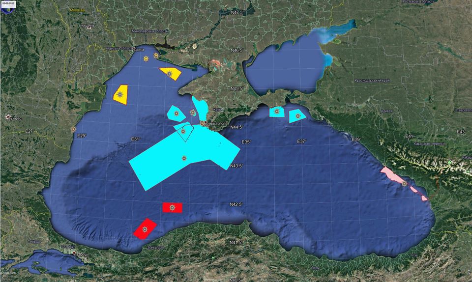 Photo 1.
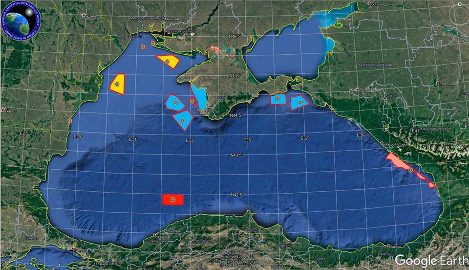
Photo 2. (Ukrainian naval forces in yellow, Georgian naval forces in pink, Turkish naval forces in red, Russian Black Sea fleet in blue).
* * *
NAVTEX (NAVigational TEleX) is an international automated warning service for delivery of navigational and meteorological warnings as well as urgent maritime safety information (MSI) to ships. NAVTEX is also a major element of the Global Maritime Distress Safety System to secure safety to the International Maritime Organization (IMO) according to SOLAS Convention #74/88. The information is transmitted via narrow-band direct printing on medium-frequencies of 518 kHz (in English only). Other states (except for the US) are able to use 490 kHz to broadcast in local languages. When bad weather conditions near the Suez Canal (which is close to the desserts of Egypt and the Arabian Peninsula) form dust screens and prevent the use of 518 kHz, another duplicate HF at 4209.5 kHz should be used.
More on the topic
- 24.06.2024 The Black Sea Report (Part 1 NEW). Losses of the Russian Navy in the Black Sea in 2022-2024. Updated database
- 14.06.2024 The Black Sea Report (5): The situation in the Black Sea as of April 2024 and ways to improve the AFU performance
- 14.06.2024 The Black Sea Report (4): Summary of the 2022-2024 Developments in the Black Sea Theater of Operations
- 11.06.2024 The Black Sea Report (3): The main tasks of the Black Sea Fleet as of February 24, 2022
- 10.06.2024 The Black Sea Report (2). Composition of the Warring Parties' Forces and Russian Black Sea Fleet Objectives at the Opening Stage of Aggression
- 11.05.2024 The Black Sea Report (Part 1). Situation in the Black Sea During the Russian Aggression Against Ukraine in 2022-2024.
- 26.02.2020 Closure of the Black Sea on February 25, 2020
- 25.02.2020 Closure of the Black Sea on February 23, 2020
- 18.02.2020 Closure of the Black Sea on February 17, 2020
- 02.02.2020 Closure of the Black Sea on February 1, 2020
- 01.01.2020 Closure of the Black Sea on the last day of 2019
- 10.09.2014 All Russian Black Sea Fleet assault ships return to the Black Sea by September 7 - details