Russian Federation Blockade of the Mariupol and Berdyansk Ports: trends and statistics
Andrii KLYMENKO
Head of the Maidan of Foreign Affairs and Black Sea Institute of Strategic Studies monitoring group, the BlackSeaNews editor-in-chief, Yalta-Kyiv
Translated by Tetyana PUCHKOVA
For the first time, the joint monitoring group of the Maidan of Foreign Affairs, the Institute of Strategic Black Sea Studies and the BlackSeaNews online portal presents the summary and analysis of the detentions of sea vessels headed to and from the Ukrainian ports in the Sea of Azov — Mariupol and Berdyansk — by the Coast Guard of the FSB Border Service of the Russian Navy.
As soon as the dimensions of the Kerch Bridge became known almost two years ago, it became obvious that Russia would use the Kerch Strait to hinder Ukraine. With the 33 meter clearance and a particular geometry, the bridge cut off almost half of the previous sea traffic, so the marine business had to pursue alternative options. And being familiar with the enemy’s thinking mode, I have no doubt that it was precisely the ports’ success in attracting new fleet that prompted Russia to apply new means of the economic blockade.
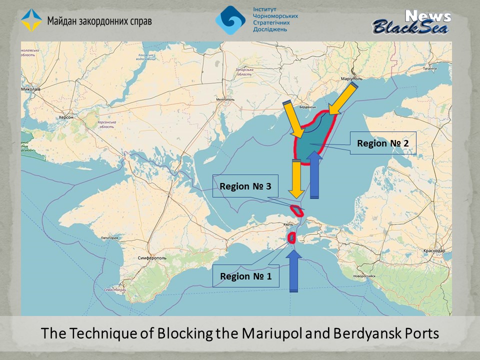
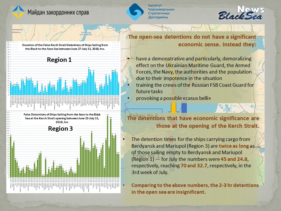
The first slide below spells out the technology of blocking the Mariupol and Berdyansk ports that on April 27, 2018, started selectively, but already on April 30 became complete, when, according to the State Border Guard Service of Ukraine (BPSU), the RF border guards of the FSB began inspecting every ship destined for Mariupol and Berdyansk, marked on the map as Region1.
At first, that did not lead to a significant delay and was not the subject of our monitoring. But in the 3rd week of June the waiting times for ships in Region 1 in the Kerch Strait en route from the Black Sea to the Sea of Azov became horrendously long— 20-30 hours instead of the usual 2-5 —, so staring with June 26, the Monitoring Group has been including it in its daily monitoring (see the Database).
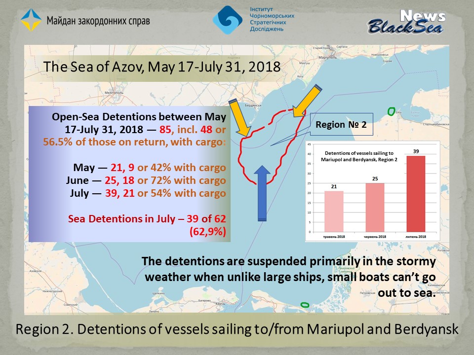
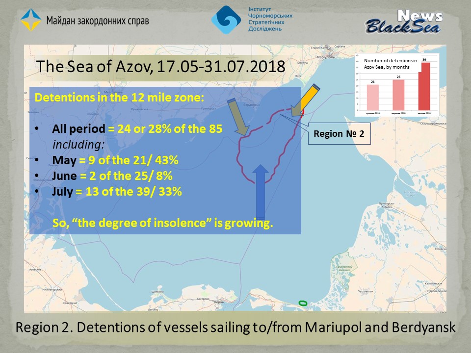
Since May 17, 2018, the vessels of the RF Coast Guard of the Federal Security Service began mass detentions of all ships sailing to/from Mariupol and Berdyansk, including those on the move in the middle of the Azov Sea, for inspection and identification of crew members. Such detections had taken place previously, but only on a selective basis. All these detentions take place in the area marked on the map as District No.2. Since May 17, 2018, they have become the subject of our monitoring.
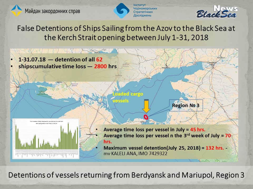
On June 23, 2018, the Monitoring Group noticed a sharp increase — in comparison with the traditional several hours — in waiting times for ships sailing from Mariupol/Berdyansk for the permission to pass through the Kerch Strait in the opposite direction — from the Azov to the Black Sea, on the map marked as Region # 3. Monitoring of that situation has yielded very interesting results.
Thus, July 2018 became the first calendar period when the Monitoring Group was able to comprehensively analyze all three components of the RF sea blockade of the Ukrainian Azov Sea ports.
Region 1:
The Kerch Strait roadstead where vessels wait for passage to the Azov Sea
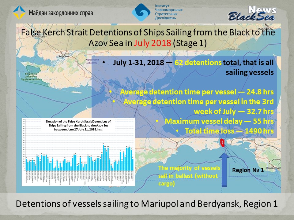
Between July 1-31, 2018, there were 62 detentions in the Kerch Strait, meaning that all ships sailing there without exception have been detained. Most of these vessels were sailing in ballast (without cargo) for Ukrainian export products (mainly metals, coal and grain, construction materials and ore).
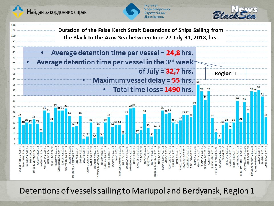
According to the monitoring data, the average delay for each vessel awaiting the passage permission amounted to 24.8 hours, that is, more than a day.
However, the average figures do not fully reflect the dynamics of process, as for instance, in the 3rd week of July, the average delay for 1 vessel amounted to 32.7 h. At the same time, the maximum registered delay was 55 hours, while the total loss of time by the Mariupol and Berdyansk destined vessels totaled 1490 hours.
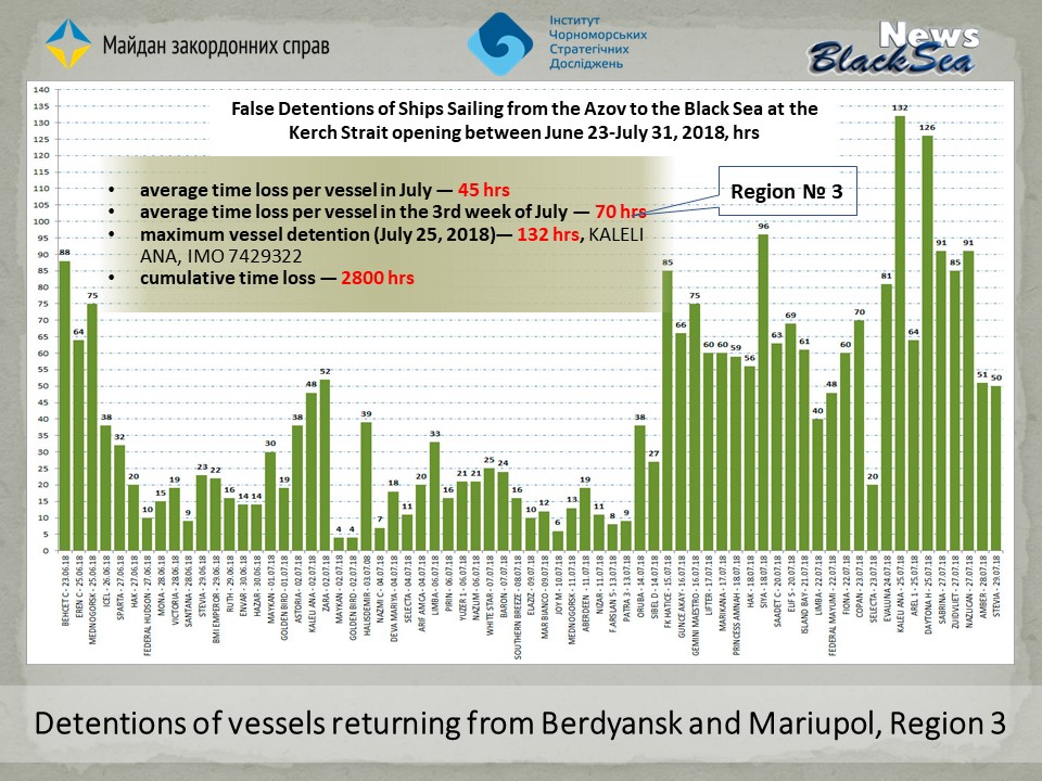
The fans of statistics can easily follow the dynamics of processes, the names of ships and the dates shown on the diagram.
Region 2: Detentions at sea
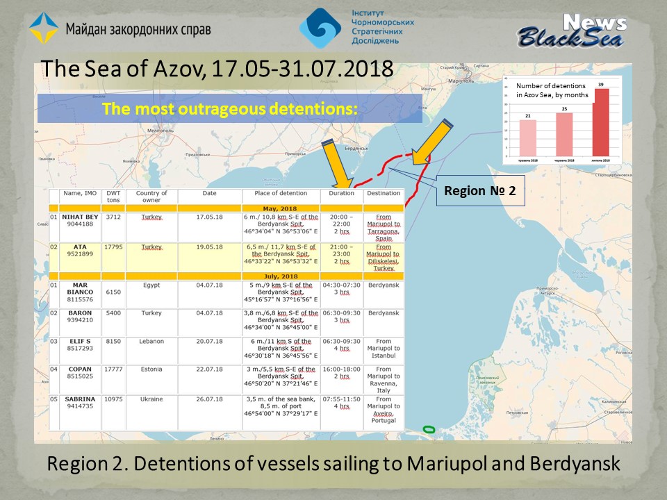
The detentions occur in roughly the same area because it covers the so-called recommended courses. The latter are the routes recommended by the Ukraine maritime services as safe for ships with a fairly large draft. Practically no vessel, regardless of whether it sails to Berdyansk or Mariupol, skips the Berdyansk turning circle and that is where the FSB's coast guard is waiting for them.
Since the first detention at sea on May 17, there has been a total of 85 detentions, of which 21 — in May, 25 — in June and 39 — in July.
About two-thirds of the vessels at sea are detained. The rest are left alone merely because during stormy and foggy weather small boats of the FSB coast guard service simply can’t go out to sea, while large cargo ships feel safe in a 2-3 scale storm. There is no doubt, that had the weather been normal, then every single would have been detained. The exception was the Russia Day wen, apparently, all boats were on the holiday parades and celebrations.
Additionally, we have created an indicator that we call «the degree of insolence». To that end, we have analyzed all the detentions according to the distance, specifically, how many detainees were closer than 12 miles to the Ukrainian coast. The reason is that all over the world that distance marks the territorial waters, but due to the shortsighted 2003 Kuchma-Putin agreement, that is not the case in the Azov Sea, either de jure or de facto.
The monitoring has shown that in May 43%, and in July — one-third of all detentions occurred at a distance of 12 miles from the coast. To clarify: in good weather the sea horizon is 30 miles or more. So all that could be seen from our Azov coast with the naked eye. There were even three-mile detentions, that is 5.5 km from Belosarai Spit, or 3.8 miles further or 7 km from Berdyansk Spit.
But the most interesting area that the July 2018 monitoring has yielded is Region 3 — the Azov Sea roadstead at the opening of the passage to the Black Sea where all vessels sailing to their destinations are already with the cargo.
Region 3: The Azov Sea roadstead at the opening of the Kerch Strait where vessels wait for permission to pass to the Black Sea
One does not have to be a professional analyst to see a sharp increase in the detention time in the middle of July on the chart. If the previous 20, 30 and 50 hours weren’t long enough, now they are kept for 70, 85, 96 and even 126 hours.
The record belongs to the Turkish ship KALELI ANA (IMO: 7429322, Deadweight: 6302 t) that was detained for 132 hours, that is, 5.5 days.
Conclusions
The main economic sense of this blockade is not in detaining the ships at sea, but in forcing those already loaded with cargo to wait 3-5 days at the roadstead at the opening to the Kerch Strait. On average, the ships wait for one day at the strait entrance and then for another 3-4 days at the exit, losing therefore, a total of 5-6 days.
The above figures prove that Russians are increasingly turning the key that the occupation of Crimea and the seizure of control over the Kerch Strait have given them.
At the same time, the open-sea detentions also play an important role, namely:
- have a demonstrative and particularly, demoralizing effect on the Ukrainian Maritime Guard, the Armed Forces, the Navy, the authorities and the population due to their impotence in the situation
- training the crews of the Russian FSB Coast Guard for future tasks
- provoking a possible «casus belli».
More on the topic
- 17.10.2023 The operations of the Ukrainian temporary maritime export corridor from the ports of Greater Odesa (the database as of 16/10/2023)
- 01.07.2023 Foreign Merchant Ships Calling at Russian Ports Before Proceeding to the Ukrainian Ones
- 08.04.2022 Blocked ships in Ukrainian ports during the war: The port of Mariupol
- 28.03.2022 Blocked ships in Ukrainian ports during the war: The Berdiansk port
- 15.03.2021 Illegal Visits to Crimean Ports by Foreign Merchant Ships (Except Russian Ones) in 2020
- 22.10.2019 Blocking the Ukrainian Azov Sea Ports: a Significant Increase Under the Storm Guise
- 12.07.2018 Database of Vessels en Route from Mariupol to Berdyansk Detained by the RF Coast Guard of the Border Service of the FSB in the Azov Sea
