The «War of Exercises» in the Black Sea: A New Very Dangerous Stage that Cannot Be Ignored
Andrii Klymenko
Editor-in-chief of BlackSeaNews,
Head of the Monitoring Group of the Black Sea Institute of Strategic Studies,
Coordinator of the Maritime Expert Platform.
On 21-22 July 2020, during the Ukrainian-American international naval exercise Sea Breeze 2020, an event took place in the Black Sea that despite being reported by many media outlets did not receive much publicity in the world during the summer vacation season.
We will pay tribute to the self-possession of the military. At the same time, this is a completely new stage in the hybrid (so far) war in the Black Sea.
That is why the Monitoring Group of the Black Sea Institute of Strategic Studies and BlackSeaNews, together with other experts of the Maritime Expert Platform, have decided to analyse this dangerous incident in detail.
* * *
On 21-22 July 2020, (as far as it can be understood from the habitually concise messages of military press services), the following happened in the Black Sea.
«Ukrainian ship formations met with other ships of the participating countries at the Black Sea rendezvous point and started joint work on a set of practical actions as part of a multinational task force.
The main purpose of the exercise was practising NATO-standard maritime operations aimed at ensuring peace and security in the crisis region.
One of the first episodes of the exercise included patrolling certain sea areas in the mode of active radio information exchange, practising tactical manoeuvring to dodge enemy attacks, and repelling small-scale high-speed targets at sea with the use of weapons.»
On 21-22 July 2020, all NATO warships and some Ukrainian ships that were in the Sea Breeze 2020 exercise area in the Black Sea heard the following warnings broadcast in Russian over an open maritime radio channel:
"... You are in an area closed to navigation, coastal warning 359/20. I recommend and require that you leave the area closed to navigation. Gunnery exercises will be conducted in this area. We are not responsible for any damage to your ship.
Also, your exercise is taking place in the exclusive economic zone of the Russian Federation. We regard this as a provocative action. I am Whaleboat three hundred and fifty-one."
BSN’s reference. Whaleboat 351 is a radio call sign of the Bezuprechnyy border patrol vessel, hull number 351. A border patrol vessel, in this case, is a 3rd rank ship (small corvette) of Project 22460 Okhotnik of the Coast Guard of the Border Service of the FSB of the Russian Federation (In Russian: Пограничное управление Федеральной службы безопасности Российской Федерации по Республике Крым), based in occupied Sevastopol.
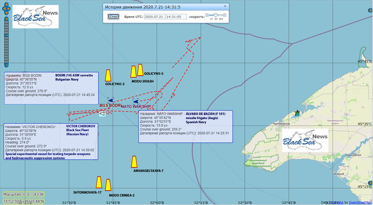
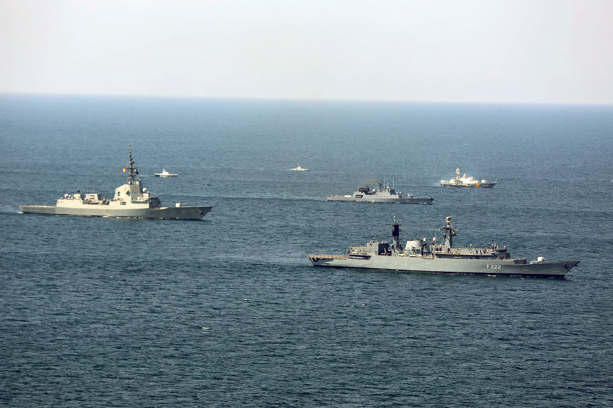
The editorial team has learnt from its sources that the same warnings were received by the flagship of the Standing NATO Maritime Group 2 – now it is the frigate of the Royal Spanish Navy ESPS ÁLVARO DE BAZÁN (F 101) on rotation – and by the corvette of the Bulgarian Navy BGS BODRI (14).
We should immediately note that the warships participating in Sea Breeze 2020 ignored this requirement of the Russian ships.
So, let us look at the two separate topics of the radio message of the Russian Bezuprechnyy border patrol vessel (351):
1) the "exclusive economic zone of the Russian Federation",
2) the "closed area where the gunnery exercises will be conducted".
1. The Location of the Events
According to online monitoring systems for ships and vessels in the Black Sea, on 21-22 July 2020, Sea Breeze 2020 ships were located in the north-western part of the Black Sea, namely between the Holitsynske, Arkhangelske, and Shtormove offshore gas fields on the Ukrainian shelf in the Black Sea (See Nautical Chart 1).
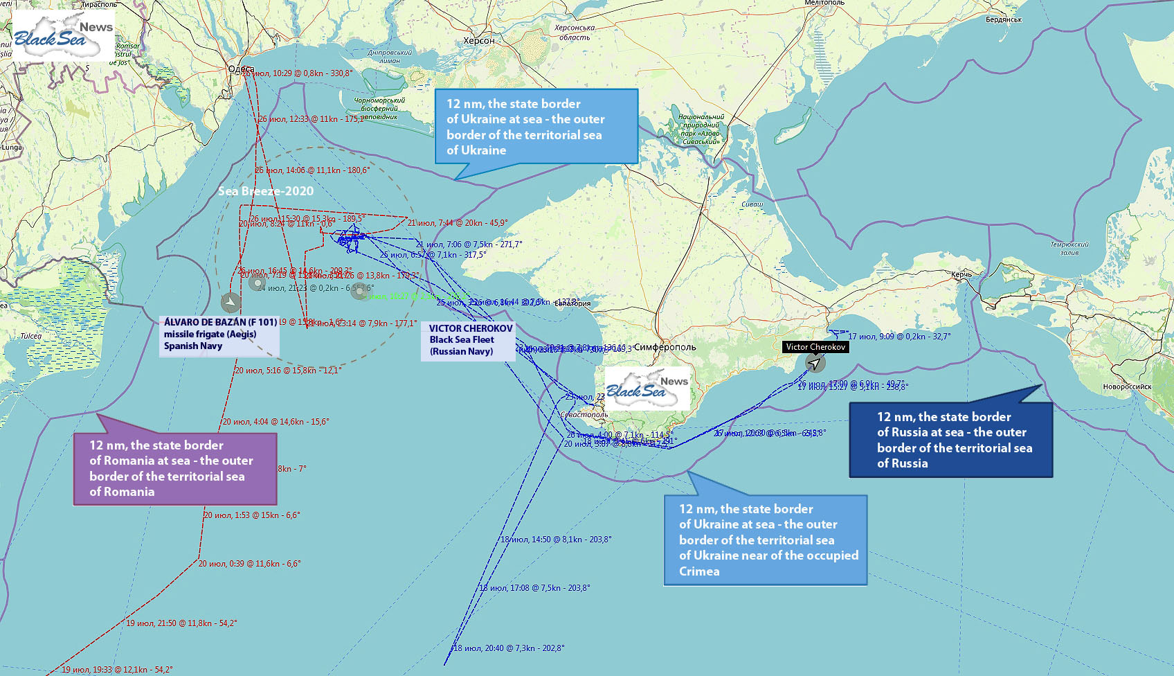
Let us look at the Sea Breeze 2020 exercise area – marked with a dashed line – from a greater distance (See Nautical Chart 2):
Finally, Nautical Chart 3 shows:
(a) distances from the seized gas platforms on the Ukrainian Black Sea shelf,
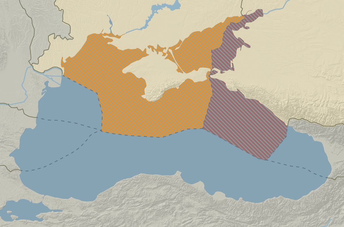
(b) the occupied part of the territorial waters of Ukraine around the Crimean Peninsula,
(c) the occupied part of the territory of the (maritime) exclusive economic zone of Ukraine along the coast of the Crimean Peninsula and the Ukrainian continental shelf adjacent to the coast.
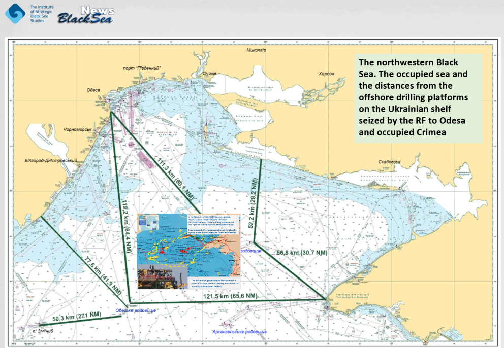
Note that the seized Odesa field is closer to the coast of Odesa than to occupied Crimea.
The distance from the nearest seized Russian drilling rig to the coast of the Odesa region is 77.6 km (41.9 miles), to Zmiinyi Island – 50.3 km (27.1 miles), and to Cape Tarkhankut in occupied Crimea – 121.5 km (65.6 miles).
From the coast of the Kherson region, the distance to the nearest seized drilling rig in the Holitsynske gas field is 52.2 km (28.2 miles).
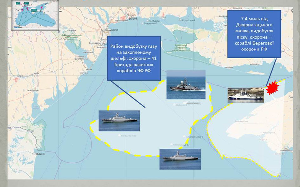
On every sea platform and every drilling rig, a garrison of Russian special forces or marines has long been deployed, as well as underwater, sea-surface, and air situation surveillance radars. (See Nautical Chart 4). There are about ten such military objects on the Ukrainian shelf.
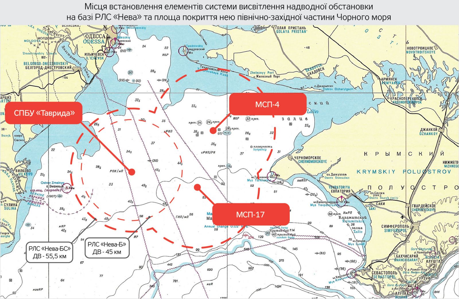
While in the past the areas of the Odesa, Holitsynske, Arkhangelske, and Shtormove offshore fields were patrolled by auxiliary ships of the Russian Federation, since 1 June 2018, the guarding of the seized Ukrainian drilling rigs on the occupied shelf has been officially taken over by the 41st brigade of small missile ships of the Black Sea Fleet of the RF. There is constant rotation, and these are the warships with significant potential (See Nautical Chart 5).
Finally, there are no recognized borders in this area of the Black Sea, except for the maritime border between Ukraine and Romania (See Nautical Chart 6).
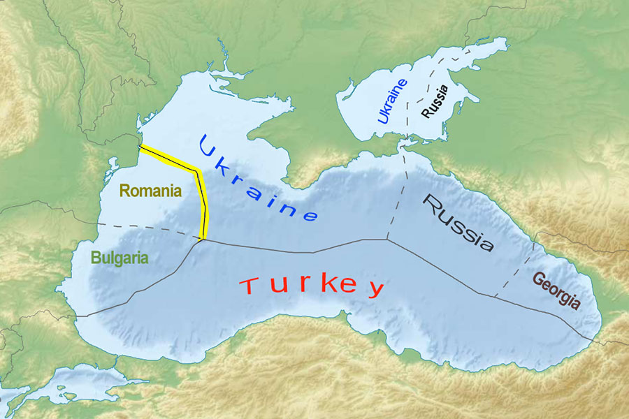
The maritime border between Ukraine and Romania was established in 2009 based on a decision of the International Court of Justice.
This is the way the maritime exclusive economic zone of Ukraine looks (See Nautical Chart 7), read details here: Maritime Borders as a Key Element of Ukrainian State Building.
The conclusion: the Sea Breeze 2020 exercise was conducted within the maritime exclusive economic zone of Ukraine, including its part occupied by Russia, outside the 12-mile zone (the territorial waters of Ukraine).
The following important theses follow from this:
The commander of the Bezuprechnyy Russian border patrol vessel, hull number 351, without a doubt, was reading from a prepared text on the air: “...your exercise is taking place in the exclusive economic zone of the Russian Federation. We regard this as a provocative action.” That is, this part of the story should be seen as an attempt to gauge the reaction of NATO naval officers.
However, it is also a signal, a defining event, after which we can predict the beginning of widespread use by Russia of the narrative such as "this is our section of the Black Sea, our Crimean fields are located here, this is our Crimean shelf, which became part of Russia in 2014 as a result of the "referendum" together with the land territory of the Crimean Peninsula."
By the way, the Monitoring Group has many reasons to believe that after Sea Breeze 2020, in late July - early August of this year, the Russian Black Sea Fleet ships were practising the techniques of defence of the offshore gas production platforms seized by Russia in the north-western part of the Black Sea.
After Sea Breeze 2020, in late July - early August of this year, the Russian Black Sea Fleet ships were practising the techniques of defence of the offshore gas production platforms seized by Russia in the north-western part of the Black Sea.
We will once again pay tribute to both NATO and Ukrainian mariners (it is said that they responded with the traditional "we have heard you"). Because if NATO ships had left that area, it undoubtedly would have been interpreted in Russia as an indirect recognition of the de facto occupation of part of the Ukrainian sea.
By the way, it was because the participants of the Sea Breeze 2020 exercise did not "get scared" and continued to carry out their plan, that neither the Russian official structures nor even the media reacted in any way to the fact that the ships participating in Sea Breeze 2020 allegedly "conducted the exercise within the maritime exclusive economic zone of Russia".
We must not relax – we must expect Moscow’s powerful move in response in the Black Sea. And soon, during the preparation and conduct of the Caucasus 2020 exercise.
We will once again emphasize:
The Sea Breeze 2020 exercise was conducted in the occupied part of Ukraine – in the maritime exclusive economic zone of Ukraine along the coast of the Crimean Peninsula and the Ukrainian continental shelf adjacent to the coast with the following exercise script:
“...ensuring peace and security in the crisis region, patrolling certain sea areas in the mode of active radio information exchange, practising tactical manoeuvring to dodge enemy attacks, and repelling small-scale high-speed targets at sea with the use of weapons”.
It looked like this (the photo by the press service of the Ukrainian Navy), and it couldn’t help but irritate the occupier:
2. Closure of sea areas
for military exercises
2.1. The Procedure
Closure of a sea area is carried out by transmitting NAVTEX messages (NAVTEX – "NAVigational TEleX"), an international automated notification system. Its technical implementation is telex:
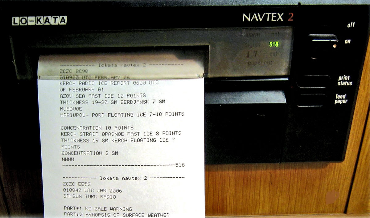
In navigation, it is used for delivery of navigational and meteorological warnings and forecasts, as well as urgent maritime safety information (MSI) to ships. It is a component of the International Maritime Organization’s Global Maritime Distress and Safety System (GMDSS) in accordance with SOLAS-74/88.
The information is transmitted in a text mode (narrow-band direct printing). NAVTEX broadcasts are made on the medium frequency of 518 kHz (in English), in countries other than the USA, the national transmission of NAVTEX also uses 490 kHz for broadcasts in local languages.
The surface of the globe is divided into 21 NAVAREAs (Navigational Areas), see Nautical Chart 8.
%20Map%20NavareasUSCGMap.jpg)
The Black Sea and the Sea of Azov are part of NAVAREA-III (its coordinator is the Spanish government represented by Instituto Hidrográfico de la Marina, Cádiz city, which is part of the Spanish Navy and, accordingly, the Spanish Ministry of Defence).
Warnings about military exercises, firing exercises, and other obstructions to navigation are issued via messages called coastal warnings.
In case of conducting exercises, they are issued by:
the Ukrainian Navy in Ukraine, the Black Sea Fleet of the Russian Federation in Russia through NAVTEX stations in Odesa and Novorossiysk respectively.
Ukrainian coastal warnings are promulgated by the Derzhhidrohrafiya State Institution, which reports to the Ministry of Infrastructure of Ukraine.
Russian warnings are promulgated by the Russian Hydrographic Service, which currently exists in the form of the Department of Navigation and Oceanography of the Ministry of Defence of the Russian Federation.
We would like to draw your attention to the following facts.
2.2. Legal Framework
The Law of Ukraine On the (Maritime) Exclusive Economic Zone of Ukraine (EEZ) does not contain any provisions that would regulate weapon exercises by foreign warships in the domestic EEZ. The issue is also not regulated by Article 411 of the Commercial Code of Ukraine titled The (Maritime) Exclusive Economic Zone of Ukraine.
Why this happened is another question. This must be corrected immediately. Laws and rules regarding the security of Ukraine within its EEZ are within the exclusive jurisdiction of Ukraine itself.
According to Bohdan Ustymenko, an expert on maritime law at the Maritime Expert Platform, Ukraine urgently needs to revise the Law of Ukraine On the (Maritime) Exclusive Economic Zone of Ukraine so that it establishes the procedure for granting Ukrainian permits for military activities, including weapon exercises, as well as research and hydrographic surveys by foreign warships within the exclusive economic zone of Ukraine; and inform the United Nations, all states of the world, and other international legal entities of the new order.
See details on this topic in the article by Bohdan Ustymenko The Issue of Legality of the Foreign Naval Military Drills Within Ukraine's Exclusive Economic Zone
2.3. How Events Unfolded in the "War of Exercises"
On 13 January 2020, we wrote the following in the article The (Un)foreseen Storm-2 – from Crimea to Odesa. Maritime Risks in 2020: The Black Sea:
Our forecast from 13 January 2020: “In 2020, one of the Russian methods for obstructing navigation in the Black Sea will be the expansion of the practice of closing the western areas of the sea for navigation under the pretext of conducting live-fire exercises, whether real or make-believe.”
Let us recall some events.
- On 1-12 July 2019, during the Ukrainian-American naval exercise Sea Breeze 2019, one of the planned exercise areas in the part of the Black Sea from the Ukrainian Zmiinyi Island near the Odesa coast to the Cape Tarkhankut in Crimea, that is, in the area where the occupied shelf with gas fields is situated, was closed (see Nautical Chart 9).
%20RF%20-%20Coast%20Warn%20Sea%20Breeze%202019.jpg)
On 24 July 2019, the RF already closed five areas in the Black Sea, including in the maritime exclusive economic zones of Bulgaria and Romania, and almost entirely the eastern Black Sea from Sochi to Turkey to hamper the Georgian-American exercise Agile Spirit 2019. (See Nautical Chart 10).
%20RF%20-%20Coast%20Warn%20past%20Sea%20Breeze%20July%202019.jpg)
The combined area of the Black Sea regions blocked by the Russian Navy in July 2019 alone far exceeded 120,000 square kilometres, or more than ¼ of the total Black Sea area. Note that in most of the areas closed under the pretext of conducting exercises no activity took place.
The goal of these actions is to form a "habitual" perception that the entire Black Sea is Russia’s zone of influence. This is Russia's strategy for driving NATO out of the Black Sea.
Since the occupation of the Crimean Peninsula, Russia has begun to implement a strategy for driving NATO out of the Black Sea.
- On 2 January 2020, closure of certain Black Sea areas as a result of issuing NAVTEX international maritime hazard warnings about conducting live-fire exercises was as follows:
%20RF%20-%20Coast%20Warn%20past%2009-01-2020%20putin.jpg)
In the largest of these areas, south and southwest of the occupied Crimean Peninsula, on 9 January 2020, the unprecedentedly large-scale joint missile-firing exercise of the Black Sea and Northern Fleets was conducted with missile launches from the sea, air, and shore (Russian President V. Putin took part in the exercise. For the first time in the Black Sea, he was demonstrated the launch of a hypersonic missile from an aircraft at a naval target.
But, as we expected, all this was just the beginning.
- On 31 January 2020, the Black Sea Fleet of the Russian Federation issued NAVAREA III warning 134/20. The coordinates of the area of missile and gunnery firing exercises of the Black Sea Fleet of the RF stated in that warning for the period 1-29 February 2020 overlapped the coordinates of the area of naval exercises of the Ukrainian Navy, stated on 28 November 2019 for the period from 1 December 2019 to 1 March 2020 (See Nautical Chart 12).
%2001-29-02-2020%20sheme.jpg)
Thus, in the period 1-29 February 2020, the situation where ships of the Ukrainian and Russian Navies could conduct firing exercises in the same area at the same time arose for the first time in the Black Sea. Note that the region, which was closed by the warning from the Russian Federation, blocked the way to the area in the Karkinitska Bay, where destructive extraction of sand was being carried out.
It is worth noting that there was no reaction, at least the public one, to such a dangerous situation, neither from the NAVAREA III coordinator nor from anyone else.
- On 21 February 2020, the situation was further aggravated – there was a double overlap of firing areas in the Karkinitska Bay (See Nautical Chart 13, 13-1):

Since then, that is, since February 2020, the situation with overlapping firing areas between the north-western coast of occupied Crimea and the coast of the Kherson region, the area of the Tendrivska Spit, has been almost permanent.
There was also no reaction to this dangerous case of overlapping live-fire exercises areas.
2.3. How the "War of Exercises" Progressed
Before Sea Breeze 2020
Undoubtedly, they well remembered at the headquarters of the Ukrainian Navy that in 2019 the Russian Federation managed to block the planned area of the Sea Breeze exercise with its coastal warning a few days before the beginning of the exercise. Then the Ukrainian Navy had to change the planned areas of Sea Breeze 2019.
Sea Breeze 2020 was scheduled for 20-26 July 2020.
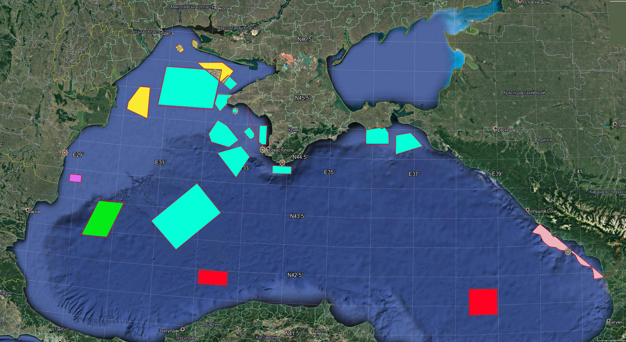
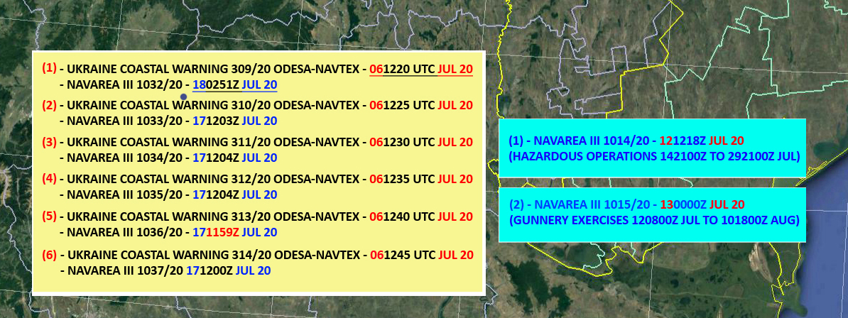
- On 6 July 2020, i.e. 2 weeks before the start of the exercise, the Ukrainian Navy issued six coastal warnings at once to "book" the necessary areas of the Black Sea.
These coastal warnings 309/20, 310/20, 311/20, 312/20, 313/20, 314/20 were published on the same day, 6 July 2020, on the website of the Derzhhidrohrafiya State Institution.
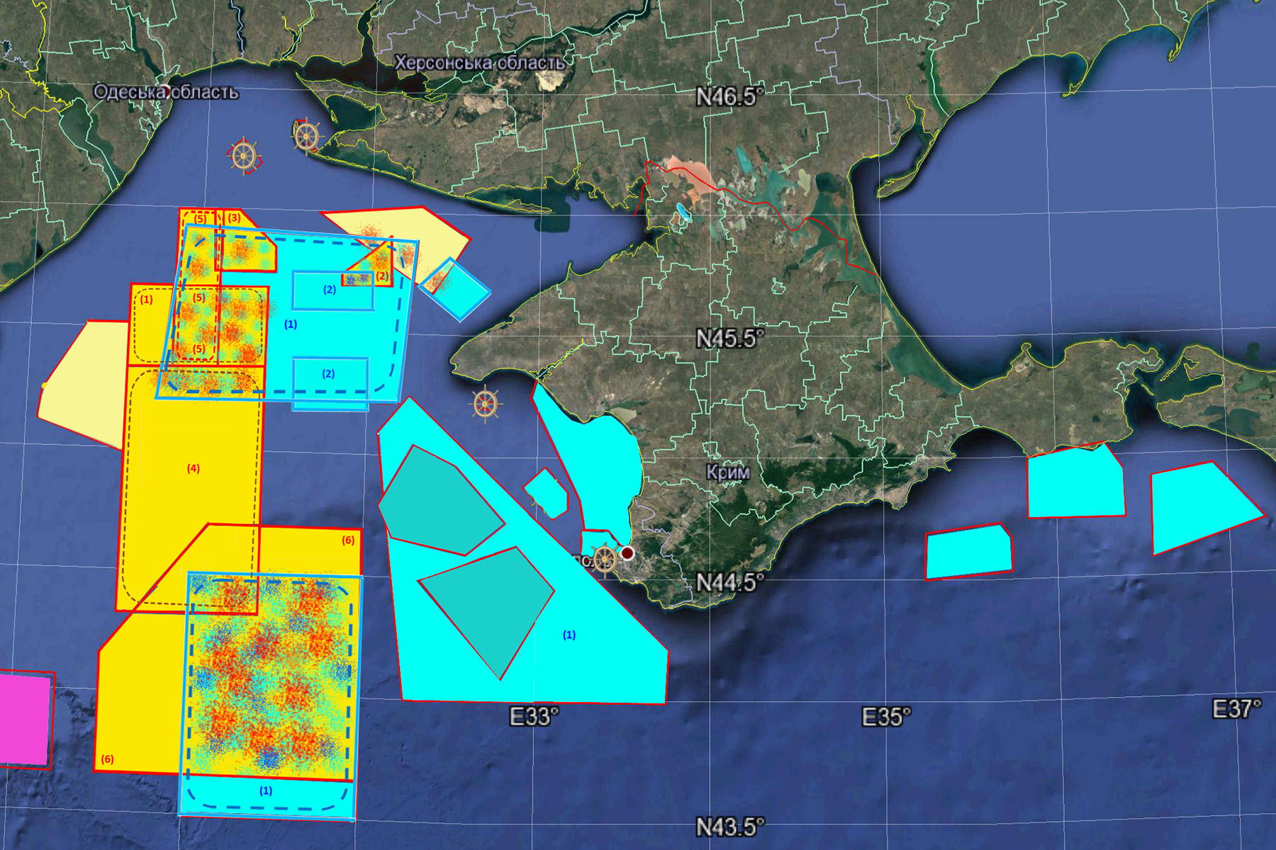
This is what the closure of the Black Sea areas for the Sea Breeze 2020 exercise should have looked like based on the coastal warnings issued by the Ukrainian Navy on 6 July 2020 (See Nautical Chart 14).
- However, the Ukrainian coastal warnings didn’t appear on the website of the Spanish Ministry of Defence, where coastal warnings that are issued and in force in NAVAREA III are published.
The map of coastal warnings in force in the period from 7 to 12 July 2020 was as follows (See Nautical Chart 15):
It is worth reminding once again that the coordinator of NAVAREA III is the government of Spain represented by Instituto Hidrográfico de la Marina, Cádiz city, which is part of the Spanish Navy and, accordingly, the Spanish Ministry of Defence.
And another interesting detail – the flagship of the Standing NATO Maritime Group 2 (frigates), which participated in the Sea Breeze 2020 was the guided-missile frigate of the Royal Spanish Navy ESPS ÁLVARO DE BAZÁN (F 101).
But that was not the end of the story. On the contrary. It acquired the traits of spy fiction and a very dangerous mess.
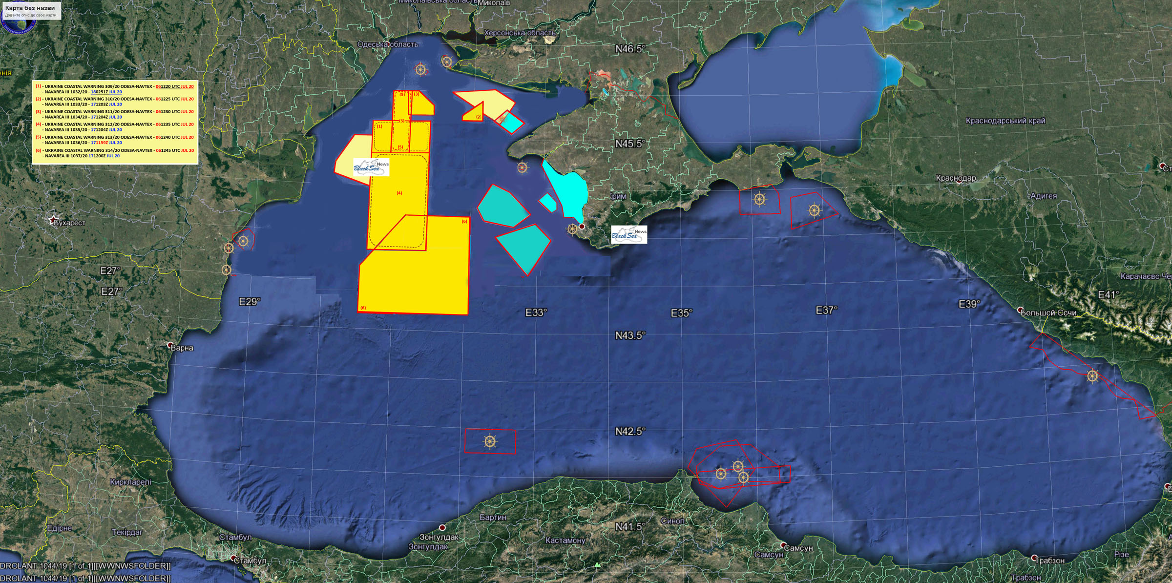
On 12 and 13 July 2020, the Russian Black Sea Fleet issued two coastal warnings declaring 5 Black Sea areas closed for conducting live-fire exercises.
Those coastal warnings were published immediately, without delay, on the NAVAREA III warnings site on the same days, i.e. on 12 and 13 July 2020 (See Nautical Chart 16).
These were the following coastal warnings:
NAVAREA III 1014/20. Date: 121252Z JUL 20. Cancel: 29220000 Jul 20;
NAVAREA III 1015/20. Date: 130016Z JUL 20. Cancel: 10190000 Aug 20)
The location of the areas declared closed by the Russian Black Sea Fleet leaves no doubt about the purpose of these "exercises", which was closing the approaches to Sevastopol and hindering the conduct of Sea Breeze 2020 in the planned areas.
At the same time, the Ukrainian coastal warnings of 6 July 2020, i.e. issued a week earlier, did not appear on the NAVAREA III website as if they did not exist.
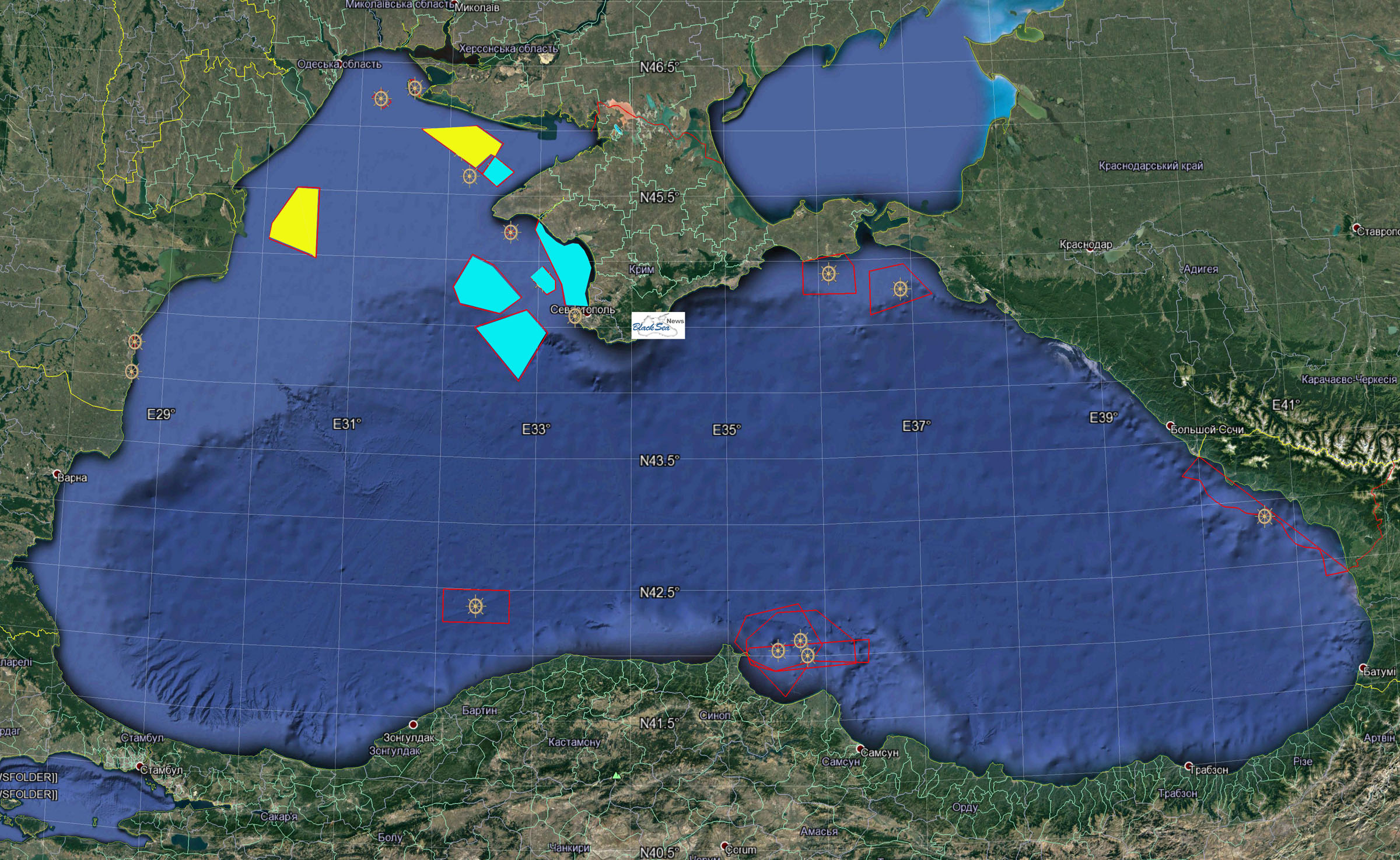
After that, the Ukrainian Navy and the Sea Breeze 2020 headquarters, as you can guess, had many causes for serious concern, and on 14 July 2020, the Ukrainian State Institution Derzhhidrohrafiya immediately turned to the coordinator of NAVAREA III and the International Maritime Organization.
Only after this appeal from Ukraine, but not immediately, on 17 and 18 July 2020, the NAVAREA III coordinator published all the six Ukrainian coastal warnings.
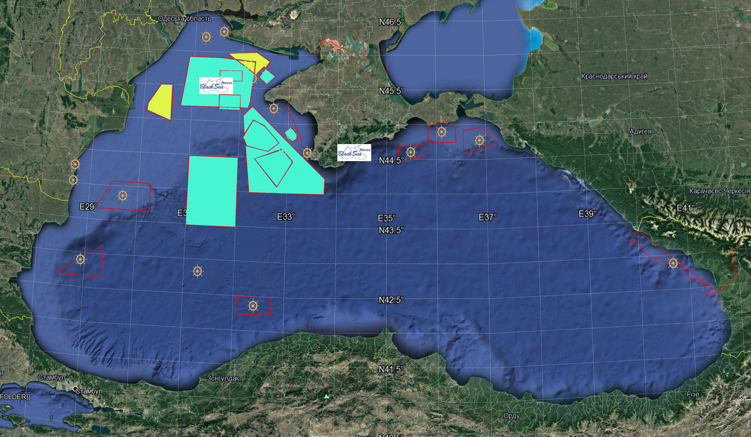
The result can be seen on Nautical Chart 17.

It is easy to see 8 areas on the map where the live-firing and manoeuvring areas of Ukrainian and NATO warships participating in Sea Breeze 2020 overlap with the Russian ones.
For convenience, we provide the enlarged Nautical Chart 17 key with the numbers of the conflicting Ukrainian and Russian coastal warnings and the dates when they were issued and published on the NAVAREA III coordinator’s website.
Also, we provide the enlarged fragment of the nautical chart showing the real situation with overlapping areas of the naval firing exercises, which had developed in the Black Sea by the beginning of Sea Breeze 2020.
After analysing that, if you go back to the first part of this investigation concerning the verbal fights on the air between NATO ships and the Russian Coast Guard, you will read it with a completely different feeling.
On 21-22 July 2020, we were actually on the verge of a military clash between NATO and Russian ships in the Black Sea.
The question arises: why did not Russia escalate the situation that time? The answer is not that complicated:
- On 20 July 2020, Russian President Putin was in Crimea, taking part in laying down two large helicopter-carrying amphibious assault ships at the seized Zaliv shipbuilding yard in Kerch. On such days, the security of the President of the Russian Federation does not allow for risky activities near the area that the head of state and his entourage are visiting.
- On 21 July 2020, snap drills to test the combat readiness of the troops and forces of the Southern Military District, formations and military units of the Russian Naval Infantry, which had been conducted since 17 July 2020 on Putin’s orders, was completed, and troops in occupied Crimea were returning to their areas of deployment. They were planning to celebrate the Navy Day in a few days, on 26 July 2020.
- The main forces of the Black Sea Fleet of the Russian Federation were already in the parade order in the main bay of Sevastopol rehearsing for another pompous celebration of the Day of the Russian Navy.
It seems that on those days Russia decided to hold one more rehearsal – how they would close the Black Sea during the preparation and conduct of the large-scale Caucasus 2020 exercise.
There is little time left before this dangerous exercise. However, we hope that there will be enough time to conduct a swift investigation and find out how and why the institution within the NATO member state’s Navy was involved in creating an extremely dangerous situation in its risky area of responsibility. It appears that the NAVAREA III coordinator from a NATO member country played on the side of NATO's main adversary.
By the way, in the course of this investigation, it would be good to quickly and decisively improve and simplify the system of displaying coastal warnings in force both on the websites of the Ukrainian Derzhhidrohrafiya and the Spanish Navy by making it more visual. In order not to have to conduct journalistic investigations to identify the authors of coastal warnings, the dates of their issuance and publication. Making these organizational and bureaucratic improvements costs very little. However, their real price is war in the Black Sea.
The editorial team would like to thank all the volunteers involved in monitoring the situation in the Black Sea. We also express our sincere gratitude to the resource https://msi.nga.mil/, which has been used to create the maps of the closed areas.